The Alpine Fault and the origin of the Southern Alps, New Zealand
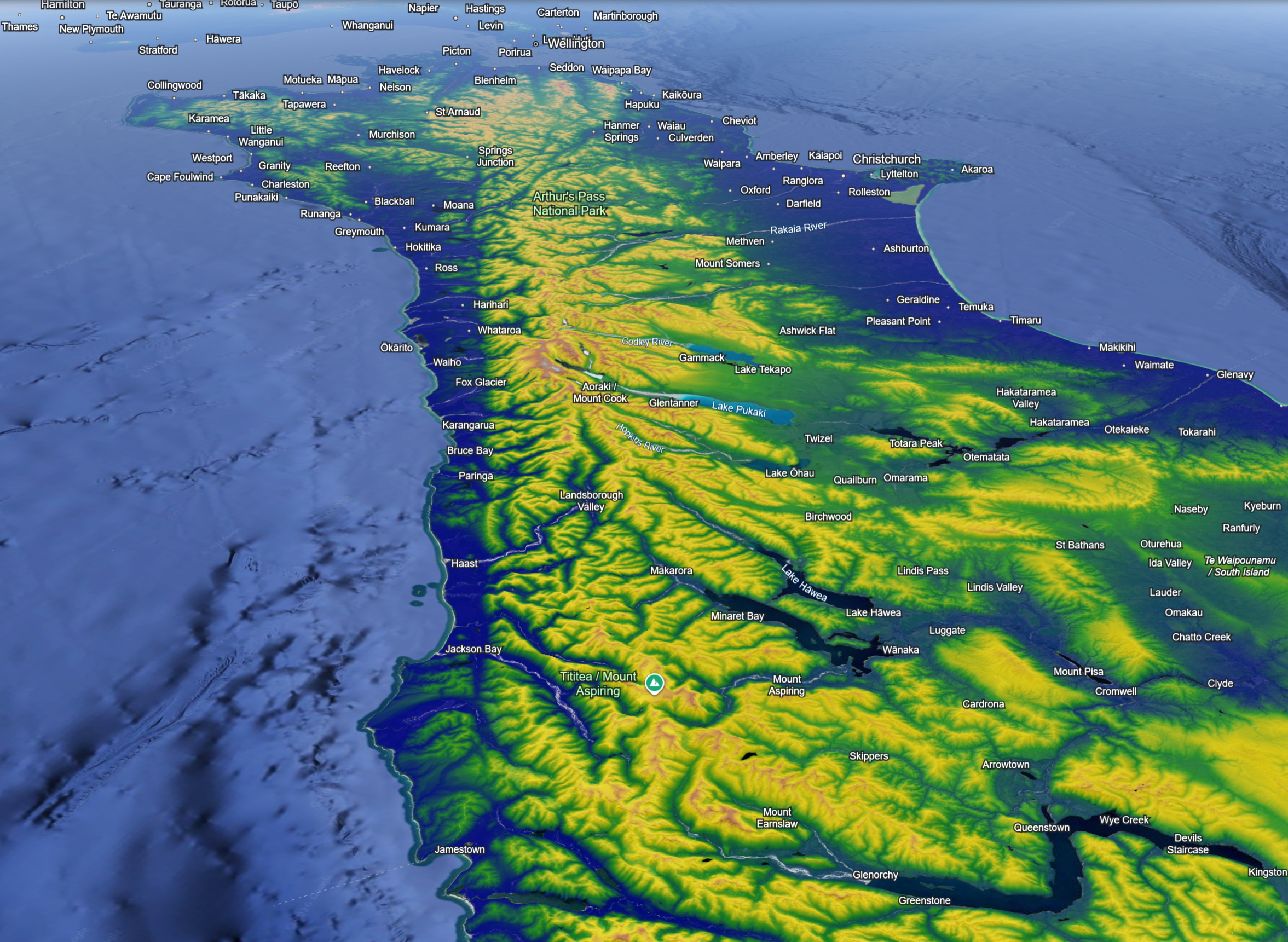
The Southern Alps dominate the skyline of South Island, New Zealand and form a rugged, mountaineous spine extending some 500km, much of the length of South Island. The highest mountains (3724m) are very steep, snow-covered year-round, and flanked by glaciers up to 23km long. But what are the Southern Alps doing there? Unlike the Alpine-Himalayan belt they didn’t form due to the collision of two continents, and unlike the Andes they’re not a volcanic-dominated mountain belt sitting above a subduction zone.
The role of the Alpine Fault, a presently active right-lateral transform fault connecting subduction zones to the north and south of New Zealand, is key to understanding the origin of the Southern Alps. It marks the boundary between the Pacific Plate to the east and the Australian Plate. The Alpine Fault is seen easily on Google Earth, expressed as an almost ruler-straight cleft through the landscape along the western edge of the Southern Alps. On the ground it is generally more subtle, often defining the break of slope between the coastal hills and high mountains.
The Southern Alps record the very latest episode in the evolution of a continent whose geological record stretches back at least 500 Million years. Zealandia, the wider area of continental crust that includes both New Zealand and the much more extensive submerged plateaux (e.g. Campbell, Challenger, Chatham), comprises a patchwork of exotic terranes welded onto the east Australia-west Antarctic margins of Gondwana between 600-100 Million years ago. The latter stages of breakup of Gondwana were marked by the opening of the Tasman Sea and the rifting apart of Zealandia from Gondwana since 80 Million years ago (see palaeogeographies in Balance & Cotterall 2009).
The Alpine Fault developed more or less in its present configuration since 25 Million years ago. Initially it connected an oceanic trench to the north of New Zealand, the Kermadec Trench, where the Pacific Plate is subducted beneath the Australian Plate, to an oceanic spreading centre in the Pacific Plate, to the south. Transform faults are plate margins that initiate as small circles about poles of rotation of tectonic plates, accommodating ‘pure’ strike-slip motion i.e. plates each side of a transform move exactly parallel to the fault. But – and highly relevant to understanding the relationship between the Southern Alps and the Alpine Fault – once formed thereafter they are forever subject to changes in plate motions.
Southward migration of the Pacific Plate pole of rotation over the last 30 Million years has led to an increasing component of compression across the Alpine Fault manifested as i) the formation of an oblique subduction zone along its southern extent, the Macquarie Ridge, with Australian Plate lithosphere disappearing beneath the Pacific Plate, and ii) lithosphere thickening, uplift and mountain building along the onshore segment of the Alpine Fault in South Island.
The present day motion vector of the Pacific Plate, defining the eastern side of South Island, relative to the Australian Plate is 43mm per annum toward the WSW (DeMets et al. 1990), comprising 41mm p.a. fault-parallel movement and 14mm p.a. compression normal to the strike of the Alpine Fault. Compression causes thickening of the lithosphere and, just as thicker icebergs sit higher in the water, leads to uplift and the creation of high topography. The time-averaged rates of uplift – or strictly speaking the rates of exhumation, the bringing to the surface of formerly deeply buried rocks – in the Southern Alps are up to 11mm per annum, among the highest measured anywhere. What is driving such rapid uplift and erosion? The answer to this question provides one of the best examples in the wider earth sciences of the interrelations and feedbacks between natural processes that used to be treated entirely separately.
Travelling through the western side of the Southern Alps you can feel immersed in temperate rain forest unlike anything we get in Europe. It is misty and humid, comprising dense evergreen forest with thick mosses, ferns and epiphytes and, crucial to the uplift story, very wet. A few kilometres upstream of the Hokatika Gorge, a popular tourist trail, the Cropp River basin receives up to 16m rain per annum, and among the highest average rainfalls recorded anywhere occur on the western side of the Southern Alps.
This is a classic example of orographic precipitation, here due to condensation from warm, moist air coming off the Tasman Sea and forced up the steep west face of the Southern Alps. The contrast between west and east is similarly dramatic – at Arthur’s Pass, rainfall reduces from 5000mm to 1500mm per annum in only 15km, with the eastern flank of the Southern Alps being characterized by warm, dry Föhn winds.
The geomorphology of the Southern Alps reflects the climatic conditions with the western side characterized by steeply graded transverse rivers, steep interfluves and high discharge rates. Erosional processes are dominated by valley lowering and highly active landslides off the interfluves. On the dryer eastern flank the relief is relatively subdued with the rivers more influenced by rock type and geological structure. The cross-sectional form of the mountain belt is therefore highly asymmetric with longer and gentler sloping rivers flowing to the east and southeast (Willett 1999).
Collectively these observations combine in a model in which compression across the Alpine Fault led to the creation of the Southern Alps, a significant topographic barrier where continued uplift has been sustained by rapid erosion promoted by high rates of orographic rainfall. In terms of exhumation we can think of deeply buried rocks being continuously extruded at the surface due to a sort of ‘pull’ force exerted by the wet climate and rapid erosion.
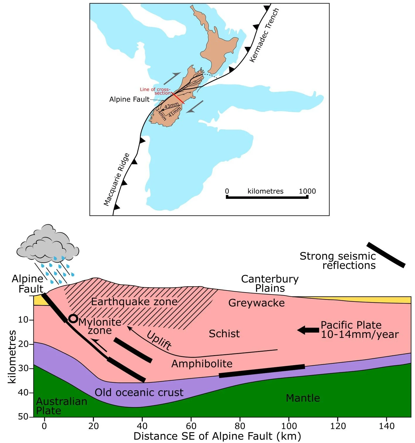
Tectonic setting of New Zealand and cross-section through South Island. The deep geometry of the Alpine Fault is speculative. Adapted from Little et al. (2005)
Perhaps a better known link between tectonics and climate occurs with the rise of the Tibet Plateau since the Cretaceous. Summer heating creates a vast low pressure system that sucks in moist Indian Ocean air, with heavy rainfall in NE India and along the southern face of the Himalaya profoundly influencing Asian climate and enhancing Himalayan erosion rates.
For the denizens of South Island living in such close proximity to an active transform fault the most obvious risk is earthquakes. The M7.1 Darfield earthquake in 2010, and the M6.9 Christchurch earthquake in 2011 were highly destructive, caused extensive damage and liquefaction and led to loss of life, but were not directly related to the Alpine Fault. The last major event sourced on the Alpine Fault occurred in 1717 (Upton et al. 2018), with an estimated magnitude of 8.2 it ruptured a 380km-long segment of the fault generating 2m coseismic (instantaneous) uplift and 7m right-lateral along-strike displacement.
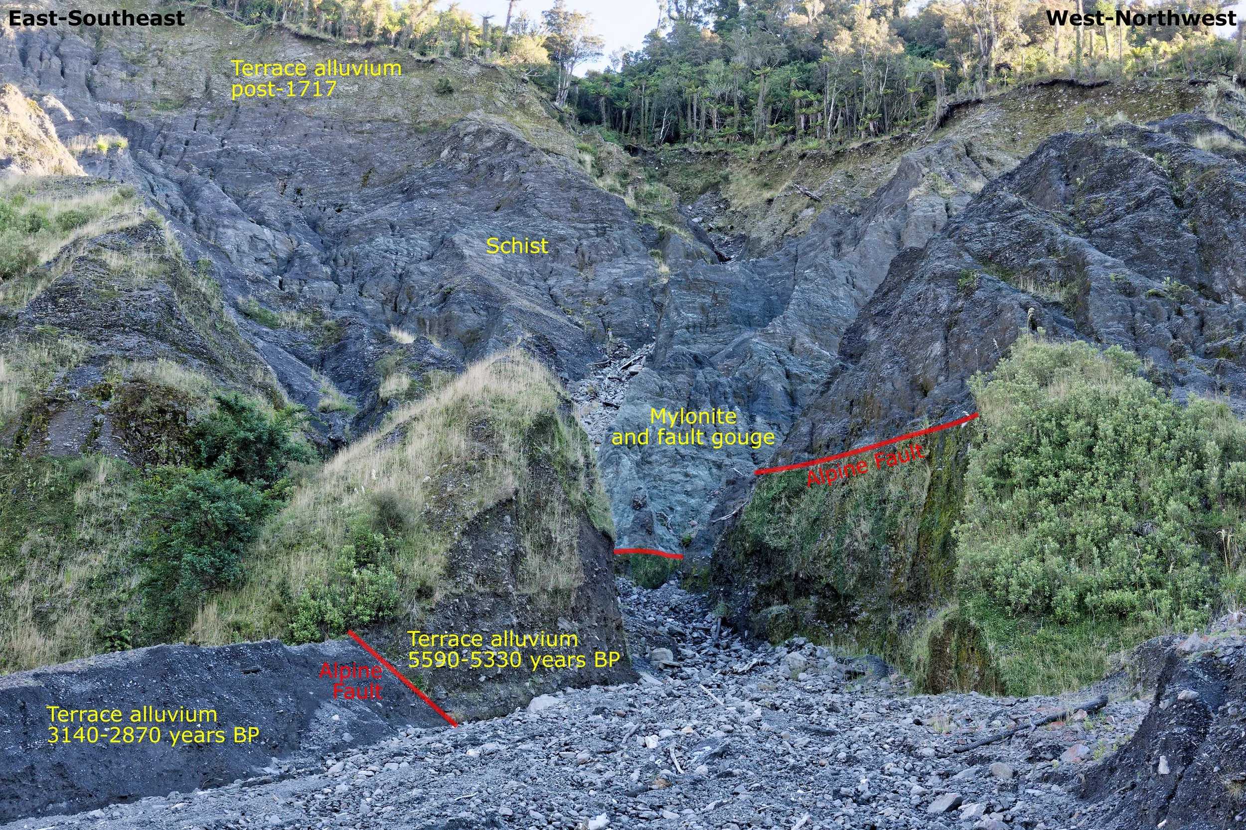
At Gaunt Creek the Alpine Fault is expressed as a 5-50cm-thick clay gouge juxtaposing mylonites (highly sheared, banded metamorphic rocks) and cataclasites (finely ground fault zone rocks) with unconsolidated late Holocene gravels (De Pascale & Langridge 2012). In another segment of the fault at Gaunt Creek 5400 year-old gravels are thrust over 3000 year-old gravels. Previous major events dated c.1615, 1430 and 1230 suggest the fault is toward the end of its ~300 year seismic cycle giving, in 2003, a 30% likelihood of a large earthquake in the next 50 years (Rhoades & van Dissen 2003). Coordinated action is being taken to prepare for this eventuality (Orchiston et al. 2018, Langridge et al. 2022).
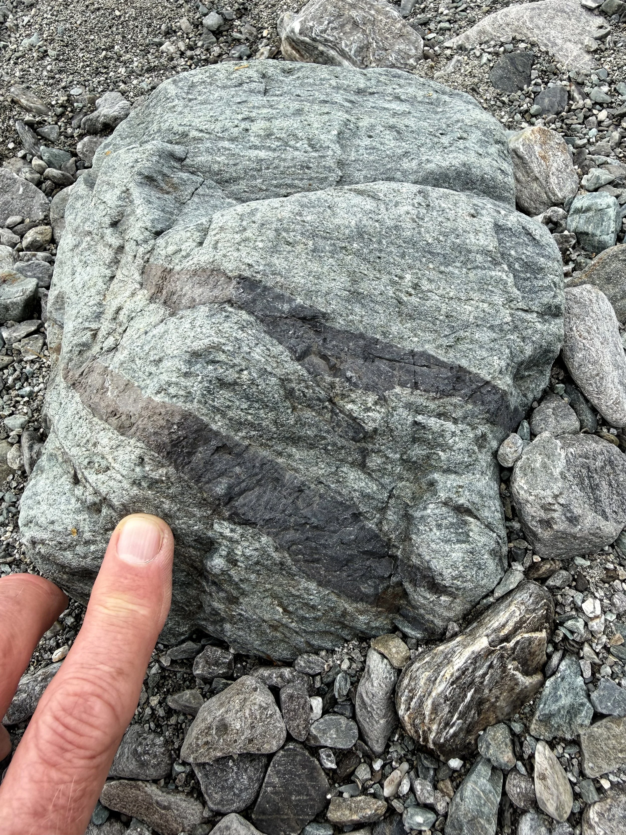
For holidaying geologists like me an equally impressive manifestation of the Alpine Fault is the endless abundance of boulders of mylonite, tightly folded schist and gneiss that form huge gravel bars in the braided streams cutting through the western Southern Alps. Of particular note is pseudotachylite – friction-melted fault zone glass occurring as thin veins and flame-like wisps of what looks like obsidian. Loose blocks of pseudotachylite scattered among the river gravels in Harolds Creek formed at 3.5-5km depth only ~570,000 years ago (Warr et al. 2007), yielding an exhumation rate of 6-9mm per annum, remarkably consistent with exhumation estimates from analysis of historical landslides (Hovius et al. 1997) and Ar40/Ar39 dating of fault zone hornblendes (Little et al. 2005).
Hokatika Gorge looking toward the Cropp River basin, western Southern Alps
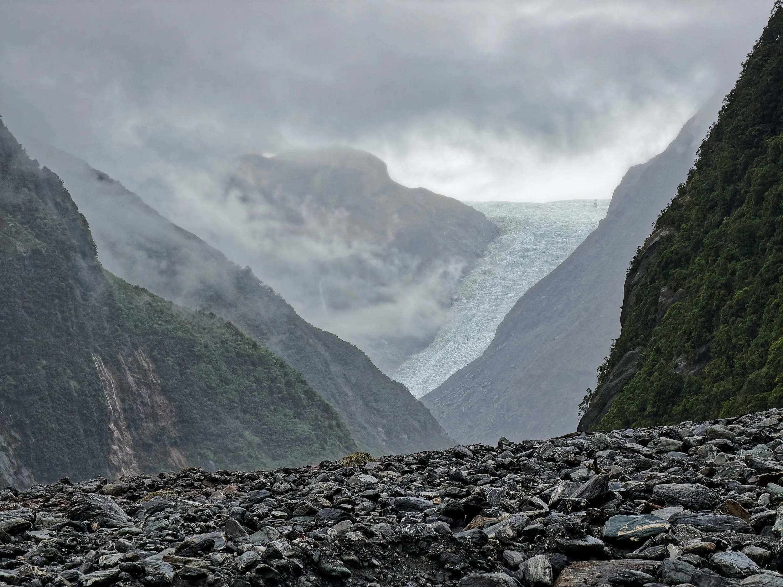
Fox Glacier and freshly eroded boulders brought down by frequent debris flows, western Southern Alps
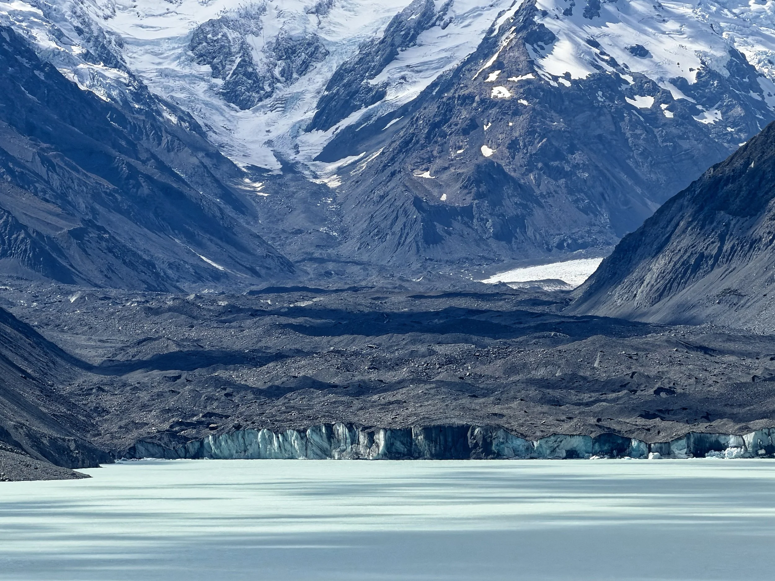
Tasman Glacier and moraine, eastern Southern Alps
Alpine Fault at Gaunt Creek - schist and fault gouge in the overriding Pacific Plate thrust over ~3000 year-old river gravels on the Australian Plate
Pseudotachylite veins from the Alpine Fault at Harold Creek formed at 3.5-5km depth ~570,000 years ago
References
Balance, P. & Cotterall, L. 2009. New Zealand geology: an illustrated guide. Geoscience Society of New Zealand Misc. Pub. 148. Free e-book https://www.geotrips.org.nz/downloads/Ballance_NZ_Geology-V2.pdf
De Pascale, G.P. and Langridge, R.M., 2012. New on-fault evidence for a great earthquake in AD 1717, central Alpine fault, New Zealand. Geology, 40, pp.791-794.
DeMets, C., Gordon, R.G., Argus, D.F. and Stein, S., 1990. Current plate motions. Geophysical journal international, 101, pp.425-478.
Hovius, N., Stark, C.P. and Allen, P.A., 1997. Sediment flux from a mountain belt derived by landslide mapping. Geology, 25, pp.231-234.
Langridge, R.M., Morgenstern, R., Coffey, G.L. and Clarke, L.B, 2022. Updated Alpine Fault mapping and fault avoidance zones for priority areas in the West Coast region. GNS Science 63p. Consultancy Report 2022/08. https://ttpp.nz/wp-content/uploads/2024/09/CR2022-08_West_Coast_Updated_Alpine_Fault_Mapping_and_FAZ_FINAL.pdf
Little, T.A., Cox, S., Vry, J.K. and Batt, G., 2005. Variations in exhumation level and uplift rate along the oblique-slip Alpine fault, central Southern Alps, New Zealand. Geological Society of America Bulletin, 117, pp.707-723.
Orchiston, C., Mitchell, J., Wilson, T., Langridge, R., Davies, T., Bradley, B., Johnston, D., Davies, A., Becker, J. and McKay, A., 2018. Project AF8: developing a coordinated, multi-agency response plan for a future great Alpine Fault earthquake. New Zealand Journal of Geology and Geophysics, 61, pp.389-402.
Rhoades, D.A. and van Dissen, R.J., 2003. Estimates of the time‐varying hazard of rupture of the Alpine Fault, New Zealand, allowing for uncertainties. New Zealand Journal of Geology and Geophysics, 46, pp.479-488.
Upton, P., Cochran, U., Orchiston, C., Howarth, J., Pettinga, J. and Townend, J., 2018. Tercentenary of the 1717 AD Alpine Fault earthquake: advances in science and understanding hazards. New Zealand Journal of Geology and Geophysics, 61, pp.247-250.
Warr, L.N., Van Der Pluijm, B.A. and Tourscher, S., 2007. The age and depth of exhumed friction melts along the Alpine fault, New Zealand. Geology, 35, pp.603-606.
Willett, S.D., 1999. Orogeny and orography: The effects of erosion on the structure of mountain belts. Journal of Geophysical Research: Solid Earth, 104(B12), pp.28957-28981.